

Tarra Valley Loop: Balook to the Tarra Valley and back
22.8 km loop · about 8 hours · Easy to medium · Start and finish: Balook
Check track conditions before you set out
Sections close for storm damage, harvesting and roadworks. See the latest track conditions on the homepage.
The Tarra Valley Loop links Balook, high on the Strzelecki Ranges, with the Tarra Valley below. The Tarra Valley has some of the best cool temperate rainforest you will ever see, and many endangered Slender Tree-ferns. The Rainforest Walk to Cyathea Falls is a must-do.
Short on time? The easy 8.3 km walk from Balook down Diaper Track to Tarra Valley Picnic Area takes 3 hours or less.
The route
Balook to Balook via Drysdale Road, West Face Track, Goombala Road and the headwaters of Traralgon Creek, Mountain Hickory Track, Duncan’s Track, Butler’s Track, The Great Forest Walk, Tarra Valley Picnic Area and Diaper Track.
| Section | Distance |
|---|---|
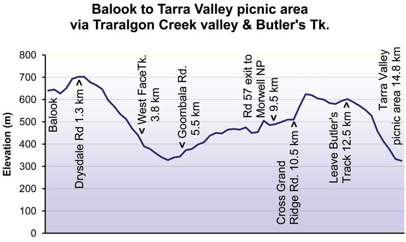
| Balook to Tarra Valley Picnic Area, via the Traralgon Creek valley and Butler’s Track | 14.5 km |
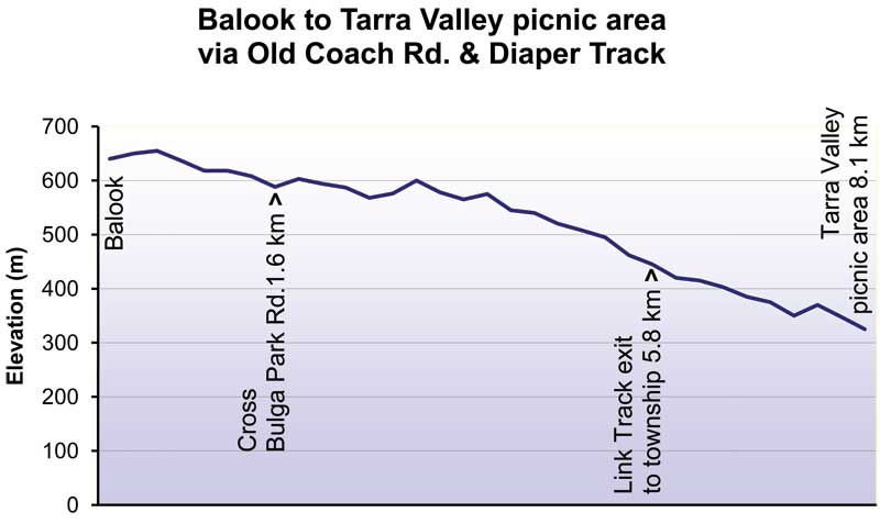
| Tarra Valley Picnic Area to Balook, via Diaper Track and Old Coach Road | 8.2 km |
Which way? Walking the loop anticlockwise means you go down, not up, the steep slopes on Drysdale Road and The Great Forest Walk.
Need to break the walk? Pattison Rest Area is a 1 km detour off Goombala Road.
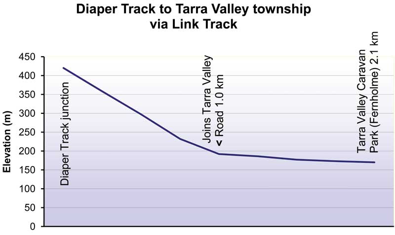
Elevation profiles
These charts come from an earlier edition of our maps, so their distances differ slightly from the table above.
What you’ll see


- Ancient rainforest and endangered Slender Tree-ferns around Tarra Valley Picnic Area, and the Rainforest Walk to Cyathea Falls.
- Tarra Falls, and small waterfalls near the track above Tarra Valley.
- In spring, blue forget-me-nots carpet the sunny spots where small streams cross Drysdale Road and Goombala Road, a legacy of early settlement.
- Dense regrowth forest in the headwaters of Traralgon Creek, replanted since the 2009 fire.
- The Great Forest Walk: a truly wild area with some massive trees, and glimpses across the Tarra Valley. The last kilometre drops steeply to the Tarra Valley Road.
- Ferny tracks, mossy boulders and a canopy of old Blackwoods on Tarra Valley Link Track.
- A view of Ninety Mile Beach from the park boundary above Tarra Valley (stay off the private farmland).
- Historic sites marked on the map, including Morningside Grange Homestead and the former Tarra Valley School and Hall.
Shorter option: Balook to Tarra Valley
The shortest way to the Tarra Valley from Balook is the easy 8.3 km walk down Diaper Track to Tarra Valley Picnic Area. You can also turn off along Tarra Valley Link Track to Tarra Valley Retreat (formerly Tarra Valley Caravan Park, Fernholme). Both take 3 hours or less.

Tarra Valley Link Track is a steep foot track that winds among moss-covered rocks and boulders beneath old Blackwoods. These are one-way walks, so arrange a pick-up or allow time to walk back up.
Is it for you?
Balook to Tarra Valley via Diaper Track is easy. The full loop, via the Traralgon Creek valley, is easy to medium, with some steep slopes and narrow foot track.
The Grand Strzelecki Track as a whole is a Class 4 track: narrow in places, with minimal facilities, so you’ll need to be self-sufficient and able to navigate. Winters are cold, it rains a lot, and it gets colder as you climb. See Before you go for the weather and what to pack, and read the Track Protocols.
Walkers’ stories
Read how others found it: Richard’s walk (2020), Deb’s walk (2018) and Daniel’s trail run from Balook (2016). For a shorter taste of this loop and the Mount Tassie Loop, read Richard’s 11 km walk on Goombala Road, West Face Track and Drysdale Road.
Stories describe the track at the time. Check the homepage for current conditions before you go.
Facilities
- Tarra-Bulga National Park Visitor Centre (Balook): public toilets and water, electric barbecues, picnic tables and a shelter.
- Tarra Valley Picnic Area: car park, information, picnic area, toilets and a shelter.
- Pattison Rest Area (Balook): a free rest area for walkers with swags or small tents, with a toilet, small shelter and water tank (treat the water before drinking). Camp on the western edge of the clearing and keep off private property.
- Tarra Valley Retreat (formerly Tarra Valley Caravan Park, Fernholme): paid campsites and cabins. Bookings are required.
- More places to stay are in Where to stay and camp.
If you need to cut the walk short: leave Goombala Road at Pattison Rest Area for an easy walk back to Balook along the sealed Grand Ridge Road. The track also crosses Grand Ridge Road at the top of Tarra Valley Road.
Track rules: no wood fires anywhere on the track (use a fuel stove). No cats, dogs, horses, firearms or generators in Tarra-Bulga and Morwell National Parks (Parks Victoria policy).
Getting there
Balook is about 2.5 hours from Melbourne. Take the Princes Highway to the Yarram / Loy Yang exit, turn right at the traffic lights just before Loy Yang Power Station, then follow the brown tourist signs to Tarra-Bulga National Park and Balook. The Traralgon–Balook Road from Loy Yang is sealed.
From Yarram, follow the signs north through Tarra Valley to Balook. More options, including public transport, are on Plan your hike.
Get the maps
This page gives you a feel for the walk. For the route, marker posts and track junctions, use the maps.
- Printed Topographic Map 3: Tarra Valley Loop
- East loop walks map (digital, for the Avenza Maps app; covers all three loops)
- Printed Topographic Map Set of 6 (the whole track)
Photo credits: Tarra Falls by Lindsay Evans, CC BY-SA 2.0, via Wikimedia Commons (cropped); forest near Cyathea Falls by Michael Barnett, CC BY-SA 3.0, via Wikimedia Commons (cropped).

